

History of the Canecutter Way
The Canecutter Way is the old Bruce Highway that originally ran south from INNISFAIL to SILKWOOD, via WANGAN, SOUTH JOHNSTONE, MENA CREEK, and JAPOONVALE, and now includes KURRIMINE. Although new highway now skirts this area after the opening of the Centenary Bridge in 1974, it has lost none of its character and charm. The name recognises the work of the original sugar cane growers and their teams of cane cutters.
“This area, so fertile and rich, was a comparatively late windfall for arable land seekers. For over 100 years after the coastline was chartered by Captain Cook, remarkably little more than he had established was known of it. The two most prominent coastal features, Mourilyan Harbour and the Johnstone inlet, were discovered, somewhat bewilderingly, by accident in 1872 at a period when one would anticipate the coastline could provide no such major surprises.” (Quote from “Hurricane Lamps and Blue Umbrellas” by Dorothy Jones ISBN 0 909920 04 0)
Most of the land in the Johnstone Shire (now part of the Cassowary Coast Regional Council) is the traditional land of the Ma:Mu tribal group. Ma:Mu traditional lands extend west to Millaa Millaa, south to Murdering Point and Silkwood, and north through Eubenangee Swamp to Coopers Point. Towns and districts such as Goondi (elbow), Wangan (crow), Boogan (native dog), Currajah (running water) and Kurrimine (sunrise) are the original aboriginal names associated with those places.
 Other places in the area were named after early pioneers – the Johnstone River after Sub-inspector Robert Johnstone of the native Police Force – or ships that plied the rivers and ocean in the area: Flying Fish point and Coquette point are named after two cutters of that name. The Basilisk range and the township of Basilisk (adjoining South Johnstone) were named after Captain John Moresby’s cutter “Basilisk”.
Early development was defined by two catastrophic natural events. A devastating Cyclone on 29th March 1890 and a second, 28 years later on 10th March 1918. (The lowest barometric pressure recorded was 926hPa at Mourilyan sugar mill – outside the core of the cyclone – but estimates based on the height of the storm surge put the central pressure in the low 900s, well into the “super typhoon” range). Both destroyed the early settlements, with loss of life and ruined crops and orchards. It is a testament to the fortitude of early settlers that, having lost everything, (some of them twice), many stayed on to re-build and so began a period of great endeavour, innovation and growth.
WORLD HERITAGE: In 1988, about half of the original Johnstone Shire was listed as World Heritage and it contains some spectacular features of global importance. This is the oldest surviving tropical rainforest on earth. The World Heritage area is a living, breathing museum. There are more primitive plants and animals here than anywhere else on earth. There are examples everywhere – such as ancient king ferns, cycads and Kauri pines which evolved over 200 million years ago. Over half of the world’s 19 primitive flowering plant families are found in the Shire – one of the greatest concentrations on earth. It is home to rare and endangered plants and animals. The Biodiversity Strategy lists over 250 rare and threatened plant species and 45 rare and threatened animal species – the most famous, of course, being the Cassowary.
THE PEOPLE – The region’s settlers were culturally diverse. The first group were Anglo-Celtic, but were outnumbered by Aboriginals, South Sea Islanders, Torres Strait Islanders and Chinese. Now the area is also home to descendents of later migration from Italy, Spain, Greece, Malta, Yugoslavia, India, Pakistan, Philippines and Hmong refugees from Laos. This multi-cultural community continues to welcome people from many places around the world.
TOWNS OF THE “CANECUTTER WAY” (from Innisfail travelling south to Kurrimine Beach)
INNISFAIL
 In 1873 George Elphinstone Dalrymple investigated a new river described by Sub-inspector Robert Johnstone, after whom he subsequently named the twin rivers. Dalrymple also named Coquette and Flying Fish points after the expedition’s two cutters. Having chartered and named the area, he departed – to be followed quickly by the Cedar getters who cut a swath through the forest giants. Thomas Henry Fitzgerald along with James Quinn, Bishop of Queensland arrived soon after and a small town sprang up where the two rivers join, before flowing out to sea.
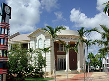
The town was originally named Geraldton, but confusion with the port town of Geraldton in Western Australia forced a name change – to Innisfail, the name of Fitzgerald’s first plantation. Sugar growing in the rich soil commenced and by 1881 work commenced on the first sugar mill; the first crush took place in January 1882. This town, of course, suffered setbacks along with others in the two great cyclones in those early years, and rebuilding after the 1918 cyclone was done in the Art Deco style of the period. Innisfail is now famous for its preserved and maintained Art Deco buildings.
Art Deco in the Tropics – Innisfail Inc. was formed in 2002 to promote and conserve the cultural heritage of Innisfail and its surrounding districts and to attract visitors to our unique town and its environment. Art Deco in the Tropics – Innisfail Inc. Website
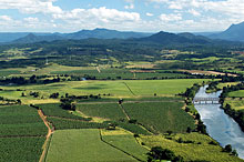
Now the Innisfail Township has a population of approx 8,300, sits on the junction of two rivers, the North and South Johnstone, and is the centre of the Cassowary Coast Regional Council containing approx 30,400 people. Innisfail is on the Bruce Highway, and the Palmerston Highway connects to the west with the Atherton Tablelands. Innisfail directly accesses over 101,000 sq kms of highly productive land growing bananas, sugar cane, tropical fruit and dairy products and many facets of aquaculture production are in operation, producing prawns and barramundi.
WANGAN
A rural and residential town, approx 7 km south of Innisfail, it is thought that the name was derived from an Aboriginal word referring to the crow.
After a sawmill in Innisfail burnt down in 1907 the proprietors shifted milling operations to Wangan, and in 1924 the North Coast railway line was completed between Innisfail and South Johnstone. The Currajah Hotel was built and opened on 1st January 1911. Part of the original building burnt down but was rebuilt and the Currajah has now served the people of Wangan for nearly one hundred years.
After World War II the town was enlarged, with new streets named after wartime places such as Kokoda and Lae.
SOUTH JOHNSTONE
South Johnstone, on the South Johnstone River, was named in 1873 after Robert Johnstone, sub-inspector of the native police. About ten years after the first sugar cane was grown at Innisfail a syndicate financed a plantation on the South Johnstone River. A mill and a cane tramway were constructed, but closed in 1891 shortly after Queensland enacted restrictive legislation for the employment of Kanaka labour. The revival of sugar growing depended on mills at Goondi and Mourilyan.
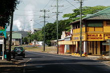 In 1911, however, a site was chosen at South Johnstone for an additional central mill. There was already a tramline branch between there and the Innisfail tramway, which led to the Mourilyan wharf. Government controlled, South Johnstone mill crushed its first cane in 1916, and it celebrated 50 years as a grower-owned co-operative mill in 1977. Throughput was increased in the 1920s with the El Arish soldier settlement cane farms. The township had five stores, a baker, a butcher, a sawmill, a school (1916) and a refreshment room in the mid-1920s, but its steady growth in population led to a more diverse array of facilities by the postwar years. The Post Office Directory (1947) recorded a Sugar Experimental station, the Bureau of Tropical Agriculture, the South Johnstone sugar mill, a foundry, a school of arts, the Plaza cinema, several stores and St Rita’s convent school (1932). The population, was then over 900, regularly swelled by casual cane cutters.
After the original Criterion Hotel and the South Johnstone Hotel both burnt down, a parliamentary edict decreed that only one liquor license ever be permitted in South Johnstone, thus the new hotel built in the 1930s was called the “Criterion Hotel South Johnstone”. The current owners (who still have the original guest book) have fully refitted the dining room back to its original standard and a secret Beer Garden and bar at the rear is being renovated. The new bar top of Mango timber may sadly put an end to the traditional ‘dancing on the bar era’, but the atmosphere lives on.
The South Johnstone Store began its life as the Howe & Carrol Merchant store in the mid 1920s. The store has changed hands many times over the years, becoming a grocery shop, then a discount store, until in 1988 it closed and became a private residence. In 2008 it was acquired by the proprietor of the adjacent Criterion Hotel and has been restored and reopened as a much needed General Store/Takeaway for the township of South Johnstone.
Off the Rails Café/Restaurant/Gallery was originally built in the early 1900s, but the earliest record of it is as the South Johnstone News agency in the 1940s. Since then it has passed through many hands until 2004 when it was bought and transformed into the Off the Rails Café. In the sugar harvesting season vehicle traffic has to stop while cane trains hauling cut cane run on the tramlines down the main street of South Johnstone to the mill nearby – hence the café name: “Off the Rails”.
This historic town was used to film the movie “All Men are Liars” (1995)
MENA CREEK
The Mena Creek area is now a flourishing area of cattle, sugar cane and banana farms, but back in the early 1900’s it was originally a source of valuable forest timber and it was the timber getters who opened up much of the land. (Ironically, large tracts of land have recently been acquired and planted with Teak and African Mahogany as part of an infant agroforestry project.)
The Hotel Mena was built and opened on New Year’s Eve 1929 by Henry Augustine Noone, the original pioneer owner of the “Stewart Creek” area, now known as Mena Creek. He changed the creek name to Mena Creek, to honour his youngest daughter, Philomena. Sadly, most of the original hotel was destroyed by fire in 1956. Re-built and improved, it is still a favourite meeting place for locals and visitors alike.
The Post Office – now the Mena Creek Post Office and Convenience store – was established in 1931 and referred to as the “little bush Post office” in various historical articles. It filled a great need in the supply of news and newspapers to a remote population cut off from time to time by swollen creeks or difficult terrain.
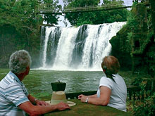 Paronella Park, a signature historical site in Mena Creek, is Spanish immigrant Jose Paronella’s dream castle in the rainforest, built overlooking the picturesque Mena Creek falls. Created in the 1930’s, Paronella Park continues to be enjoyed by thousands of visitors from around the world. Recently, Jose Paronella’s Hydro Electric generating plant, commissioned in 1933, and the earliest in North Queensland, has been restored and is now again powering the Park and feeding electricity back into the power grid. From the book “A Spanish Dreamer” by Dena Leighton, which gives a fascinating account of the history of this lifelong project, and its ups and downs:
“In 1946, disaster struck. Upstream from the Park a patch of scrub had been cleared and the logs and branches pushed into the creek. When the first rains of the Wet Season came, the whole mass began to move downstream until it piled up against a railway bridge a few hundred metres from the Castle. Water backed up until the weight broke the bridge, and the entire mass descended on the Park. The downstairs Refreshment Rooms were all but destroyed, the Hydro was extensively damaged, as was the Theatre and Foyer…”
With typical fortitude, Jose repaired and rebuilt.
JAPOONVALE
Fertile land along the banks of Liverpool Creek brought settlement to this rich farming area. It is thought that ‘Japoon’ derived from an Aboriginal word describing eels. Farm settlements at Japoonvale began in the early 1900’s. Sugar cane was transported northwards to the Goondi mill in Innisfail. Timber and other crops were taken by tramway (1910) to the Maria Creek wharf at Kurrimine Beach.
 When the South Johnstone sugar mill was opened in 1916 the tramway was continued northwards, joining Japoonvale to the mill. Almost immediately a primary school was opened at Japoonvale. It was named Stratvell, in honour of Joseph Stratford from Innisfail, reputedly the first soldier ashore at Gallipoli, and Nurse Edith Cavell. Later there was a store, a church and a public hall.
The Japoon Terraces: “The Japoon Valley is neither long nor wide; it was the merest crack in the great ocean of scrub that surrounded it, and in those days it was place of great beauty. The level floor of the Valley gave way on either side to low, graceful terraces with the dark ranges behind, watered by permanent springs, garlanded by fern-filled gullies and fountaining vegetation. Two farms wide, in the upper reaches one could almost shout from one side to the other. The terraces were ideal places for the homes of the settlers, being well drained and high enough to catch the breeze.” Grace MacDonald Baldwin in “Long Time Gone”.
SILKWOOD
 The name “Silkwood” given by AJ Daveson for his selection about 1902, was later adopted for the Post Office and settlement. Silkwood was at the junction of the tramlines from Maria Creek and Liverpool Creek/Japoonvale where bananas were grown and timber taken out. A school opened in 1916. In 1919 a sawmill was opened at Silkwood, cutting, among other things, sleepers for the Cairns to Ingham railway connection. The line reached Silkwood in 1924. Life was hard for these workers and their families, living in makeshift shelters of rough hewn timber and corrugated iron, “furniture” made from boxes, kerosene tins to carry water, scarce food and no services: The following poem tells the tale: (from Innisfail & District Historical Society publication, 1998, Vol.14)
| The Old Kero Tin (Author not known) | ||
| There was a tin we used to have in the days of long ago, And it contained home kerosene to keep our lights aglow. But when that was empty, it was not thrown away We cut the square top out of it and used it every dayWith wire handle on it (and lots of muscle too), We’d carry water from the well, the weekly wash to do. Our humble home was kept supplied with water day by day, With two of these resourceful tins, we had no other way.Dad kept a couple in the shed to hold his tools and gear, And also in the stables too, to carry stock feed there. With chopped up cane to feed the stock, we carried them along. Molasses in another one to feed the milling throng. |
Then mum would keep one on the stove with water hot and steaming, To bath us in the old tin tub and keep us clean and gleaming. At times she’d boil dad’s dirty clothes, there on the kitchen stove, We kids had one to hold our gear, a regular treasure trove.We cooked our yearly leg of ham in that old “kero tin”, We had one on our gatepost to serve as our mail bin. There was another use we had (and quite essential too), That can became a Dunny-Can, in our old outback “loo”.Then finally, all full of holes, when it had had its day, It landed on the rubbish heap and rusted clean away. And so the humble “Kero Tin” was never once abused, You could say we ‘recycled it’ (though that word was never used). |
|
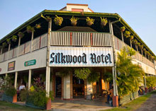
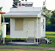
Toward the late 1920s settlers at Japoonvale and Silkwood obtained a government subsidised dairy at Silkwood. The dairy also drew on suppliers at Mena Creek and Utchee Creek, continuing until the 1940s after which many of the dairy farms changed to beef cattle. In Silkwood you can still visit the “Smallest Bank in Australia”, which is now a museum, the Silkwood Hotel, and other historic buildings.
KURRIMINE BEACH (and Murdering Point)
 An early name, Murdering Point originates from a shipwreck that occurred on the inshore King Reef a few hundred metres from the coast of Kurrimine Beach in 1878. The ship, the “Riser”, sailing North, ran aground on King Reef and was being broken up by heavy seas. Some of the shipwrecked victims came ashore in the ship’s dingy, landing on a sandy point (now removed) at the northern end of Kurrimine Beach. That evening they were attacked and murdered by local aboriginals. Some weeks later, the local constabulary from Cardwell arrived to investigate and found the remains of the bodies of the shipwrecked sailors and the signs of an aboriginal camp. This investigating party is attributed with naming the coastal protrusion, “Murdering Point”.
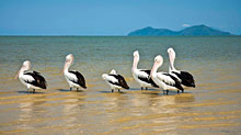
Permanent settlers, pre1918, came to Kurrimine Beach (the aboriginal word meaning Sunrise) from the south Barnard Island, but its development was fairly slow in comparison to the Mission Beach area. It was the creek that hampered early settlement spreading north from Mission Beach; one had to go inland towards El Arish to get around Maria Creek, and then travel back into Kurrimine. It was a popular beach with good fishing and easily accessible for early residents of Silkwood, and is still renowned for its good fishing and for its shallow flat beach which, at very low tides, allows one to walk to King Reef itself.
Acknowledgements: References and data acknowledged and collated from:
Queensland Government/University of Queensland website: www.queenslandplaces.com.au and the following books: “Long Time Gone” Grace MacDonald Baldwin ISBN 0 646 04238, “Hurricane Lamps and Blue Umbrellas” Dorothy Jones, “Basilisk – Township of South Johnstone” Santina Lizzio, ISBN 0 646 45797 7, “Clump Point and District” compiled by Miss Constance Mackness MBE in conjuction with the Clump Point-Mission Beach Progress Association, ISBN 0 9591796 0 7, “The Landholder’s Handbook: Johnstone Shire” ISBN 0 9752202 2 5, “Radiant Green” Mena Fallon ISBN 0 7316 9313 2, “God’s Own Country” Delia Birchley ISBN 1 86252 407 6, and personal communication with current business owners.
